Water use cases

The dynamic nature of coastal zones requires land and marine information to join forces to help monitor and protect this important ecosystem. Coastal zones experience strong land-sea interactions in terms of hydrology and response to natural hazards. These interactions are also strongly impacted by climate change and decision-making requires the combination of different information regarding the land-coast interfaces. The following use cases describe how Copernicus services support Water management.

Water quality indicators in optically complex Estonian coastal waters

Water quality indicators in optically complex Estonian coastal waters

The Baltic Sea's marine and coastal areas are heavily affected by eutrophication and pollution from various contaminants, and the Estonian coastal region is no exception. Under the Water Framework Directive (WFD), all European countries are required to report the ecological status of surface waters annually, with the goal of improving and achieving a "good" quality status.

The Cop4ESTCoast application prototype utilise Copernicus Marine products to monitor key indicators of eutrophication and water quality status (Chlorophyll-a and transparency) on a daily and monthly basis about Estonian coastal area. Regional algorithms are applied to derive transparency values from Kd490.

Stakeholders can retrieve statistical data (minimum, maximum, mean, and standard deviation) for each indicator across 16 coastal regions, facilitating WFD reporting. Additionally, nutrient levels (PO₄ and NO₃) are included for further eutrophication analysis.

In the project's second phase, water quality status classifications will be assigned to each coastal region based on their monthly average Chlorophyll-a and transparency values.

Copernicus Marine logo
SafeSwim: Protecting swimmers, surfers and beachgoers

Iberian-Biscay-Ireland

SafeSwim: Protecting swimmers, surfers and beachgoers

SafeSwim is an innovative service developed by the center Rivages Pro Tech of SUEZ with the support of Copernicus Marine National Collaboration Program to empower coastal authorities to maintain beach swimming safety in accordance with EU regulations. By leveraging data from the Marine, Climate, and Land Copernicus Services, SafeSwim delivers accurate, real-time assessments of wave-related risks at local beaches. The SafeSwim tool is designed to protect swimmers, surfers and beach goers. The service provides local authorities and lifeguards with real-time decision-support information, enhancing beach activity management all year round. It integrates historical incident data and lifeguard observations with high-resolution downscaling hydrodynamic modeling, powered by Copernicus Services. This modeling offers localized insights into wave conditions and rip current risks, enabling proactive safety measures. Authorities can use SafeSwim to inform beach goers about current and wave conditions, issue targeted warnings, and optimise lifeguard deployments. This improves decision-making, user warnings and resource allocation, ultimately enhancing beach safety. Additionally, by incorporating sea level rise projections, SafeSwim supports long-term beach swimming safety strategies, helping authorities adapt to future challenges. SafeSwim offers tangible benefits, including enhanced safety, improved decision-making, efficient resource use, EU regulation compliance, and increased public trust. Developed by the center Rivages Pro Tech of SUEZ in close collaboration with the Anglet lifeguards and municipality, this service utilises cutting-edge data to address real-world challenges, ensuring beaches remain safe and enjoyable all year.

Copernicus Marine logo
Seasonal Water Quality Forecasts for Coastal Water Quality Services

Seasonal Water Quality Forecasts for Coastal Water Quality Services

Estuarine environments are vital for both aquatic and terrestrial life, acting as dynamic transitional zones that support a wide variety of species. Water quality and habitat health in estuaries play a vital role in maintaining the overall ecological balance, providing numerous benefits to both humans and wildlife. Coastal wetland ecosystems are expected to shift landwards as a response to sea level rise. Changes in the water quality and regime (inundation extension, water depth and submersion duration) are additional factors that can significantly affect the physical condition of wetlands.

This CLimForCE coastal water quality service provides a seasonal forecast service for the LisOcean model, a water quality MOHID application that includes the Tagus and Sado estuaries (Portugal). The service uses the Copernicus Climate Change Service (C3S) Seasonal Forecast product, which provides 1° horizontal resolution meteorological variables that include predictable changes in some of the slow-varying components of the Earth system. In this service, the seasonal forecast variables are used as atmospheric forcing conditions, resulting on an operational 6-month forecast for temperature, salinity, and water quality parameters.

The service produces monthly-averaged indicators for surface coastal and transitional water bodies, as defined by the Water Framework Directive (WFD). These outputs will support water quality assessments, including the Ecological Quality Ratio (EQR), for the Portuguese Environmental Agency (APA). By aligning with end-users' needs, the project ensures the relevance of its downstream products for environmental monitoring and policy implementation.

Copernicus Marine logo
Advice4Coasts for Coastal Monitoring and Directive Reporting

Advice4Coasts for Coastal Monitoring and Directive Reporting

Advice4Coasts enables users to enhance their ability to monitor and report on marine and coastal environments in line with EU directives focusing on the MSFD and the Bathing Water Directive. Users require a software solution to integrate and analyze spatial, temporal, and additional data to strengthen reporting capacities and to support decision making for measuring campaign design and resource allocation planning.

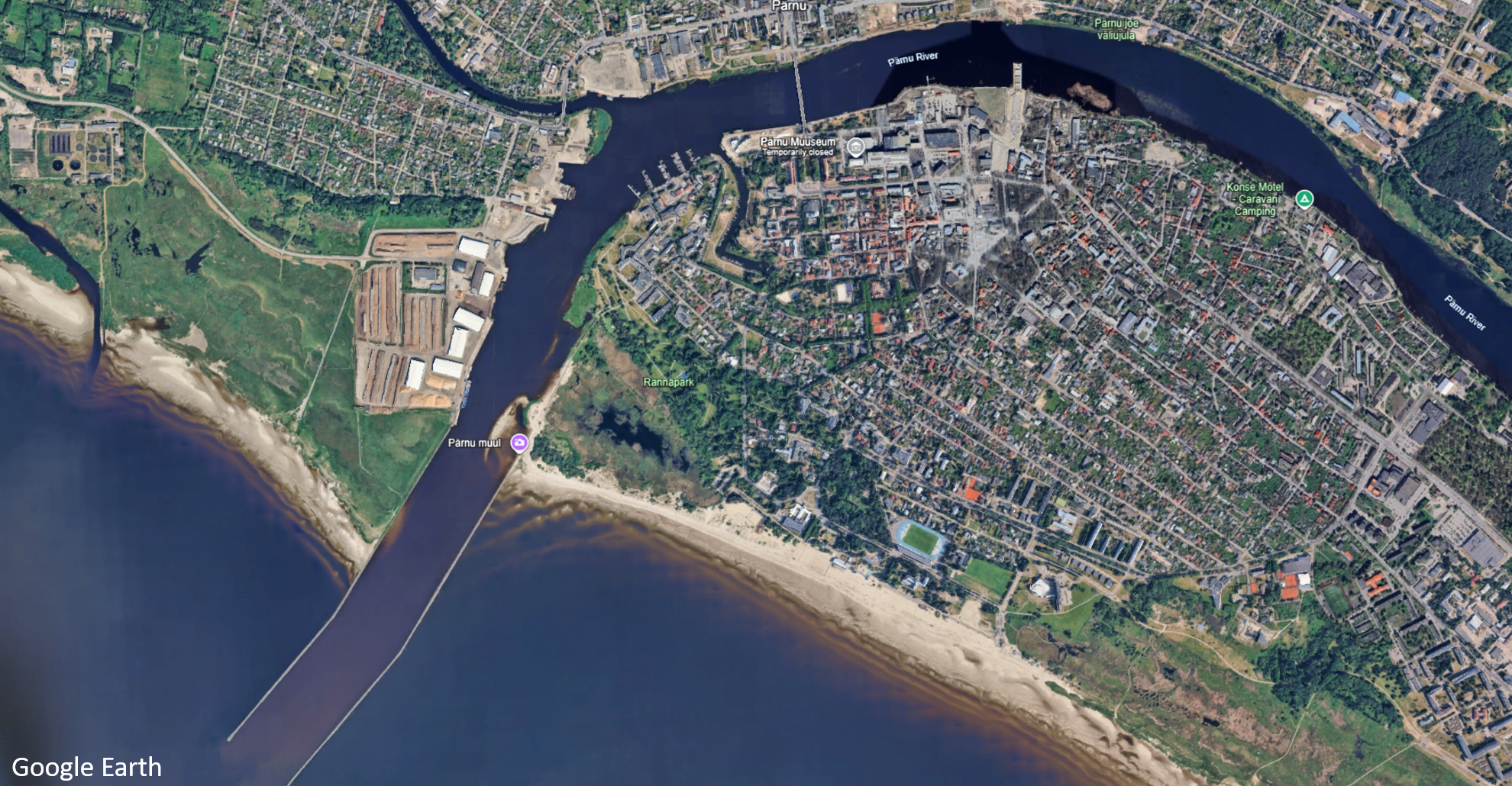
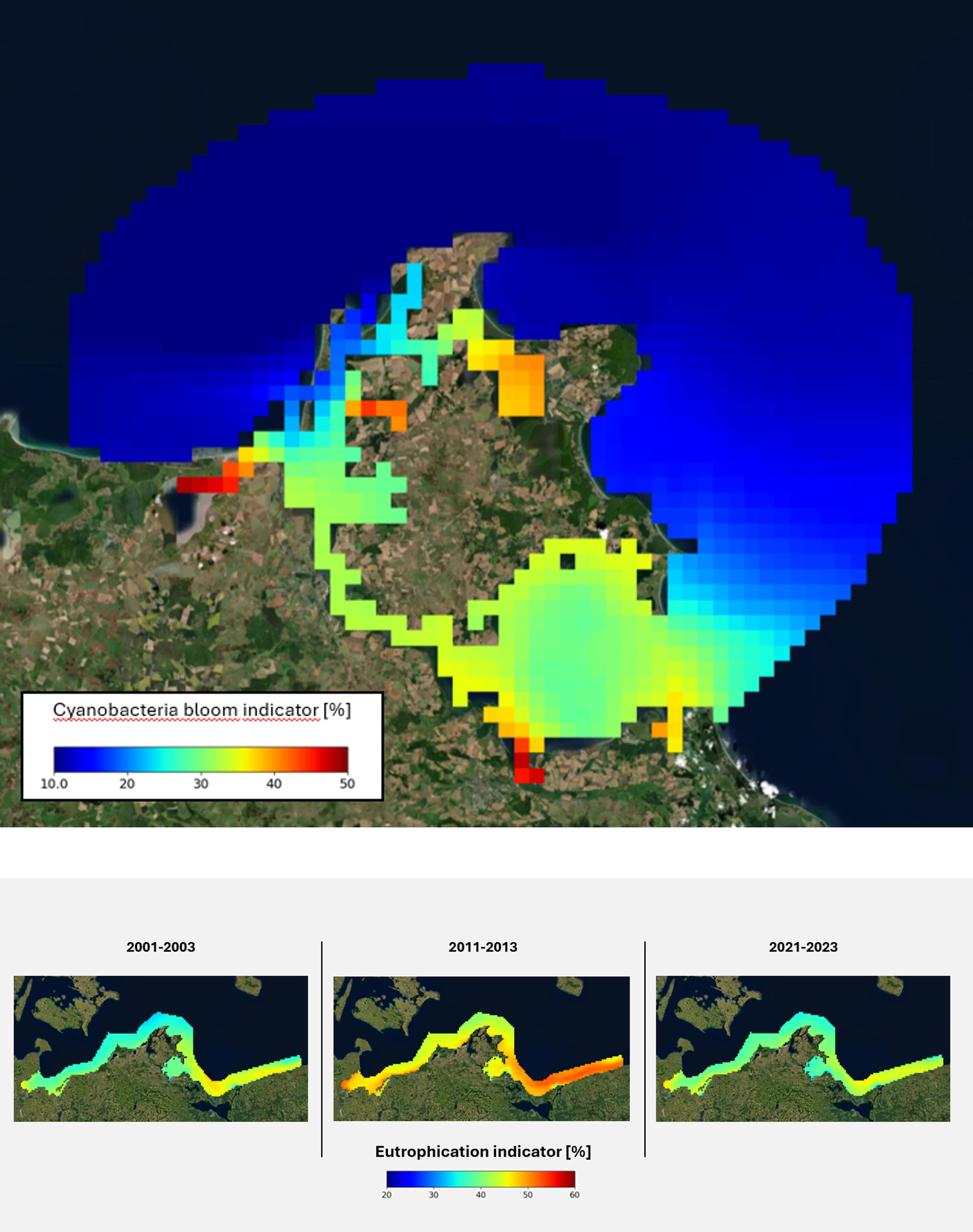
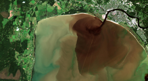
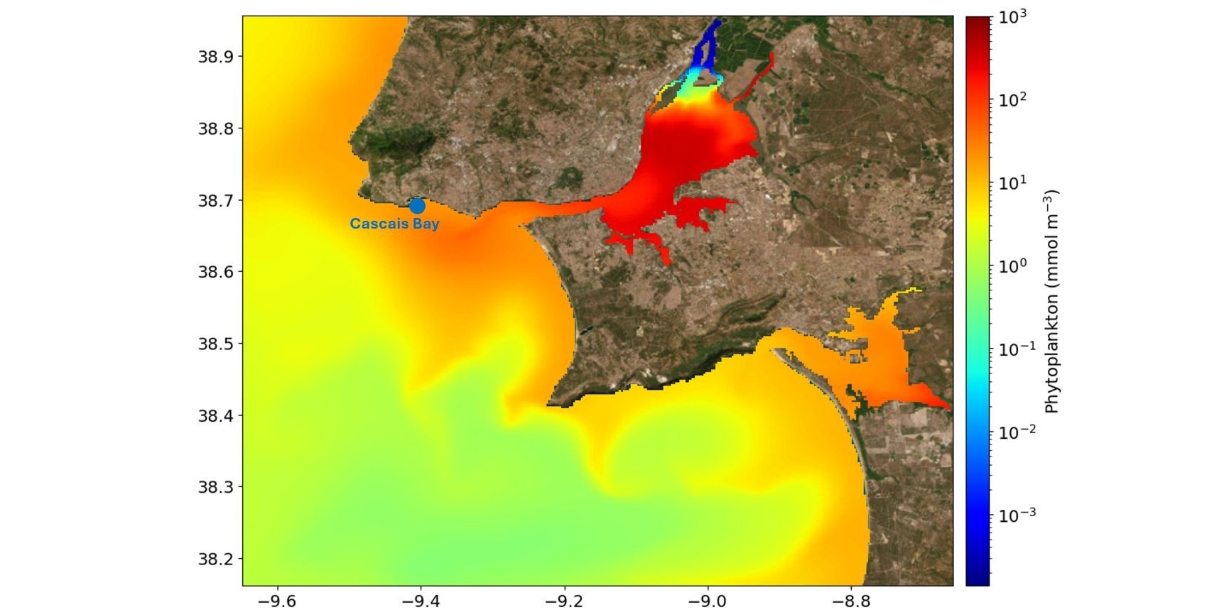
For Bathing Water Quality, the users faces challenges in predicting and monitoring algae blooms that can affect public health. Advice4Coasts leverages clowd based data fusion technologies, integrating Copernicus data and models for near real-time information and automated alerts when critical water quality thresholds, like chlorophyll concentrations, are exceeded. The platform also allows the users to combine satellite data with their in-situ measurements, providing a comprehensive view of potential risks and enabling predictive modeling of algae bloom movement, particularly in the near shore areas of the western Baltic Sea.

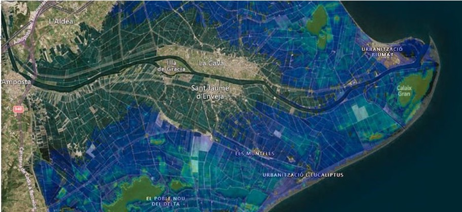
For Environmental Monitoring and Reporting, Advice4Coasts allows the users to streamline the integration of various data sources (e.g., Copernicus Marine and Land Services, in-situ measurements) and combine them in new views and analysis for monitoring environmental conditions in compliance with the Marine Strategy Framework Directive (MSFD) and the Water Framework Directive (WFD). Heat maps will be created to visualize risk areas, highlight areas of concern, support better management and conservation of coastal ecosystems.

Advice4Coasts will consolidate data in a single portal, enable merging and comparing of datasets, also for long time series and will provide analytical and statictsical features.

Copernicus Marine logo
High resolution insights into air quality problems

High resolution insights into air quality problems

Urban areas are facing a serious air pollution problem with over 80% of people in these areas exposed to unhealthy air quality levels, according to the World Health Organization. Policymakers have identified urban air pollution as a pressing environmental challenge, but addressing it requires accounting for global-scale effects while providing information at a local level. S[&]T and KNMI have developed AIR-Portal to meet this challenge - an air quality dashboard for urban areas that combines CAMS regional and global data, land use, and local monitoring data to generate high-resolution air quality forecasts. AIR-Portal is a unique service that can address urban air quality issues all over the world. The accuracy of its outputs is tested against local observations.

Copernicus Marine logo
Providing river discharges for coastal models

Providing river discharges for coastal models

River freshwater inputs are crucial in ocean modelling. They improve sea surface salinity estimations near coastlines and enhance large-scale ocean circulation predictions. Currently, most ocean models rely on climatological river discharge data. However, these have various deficiencies and lead to biases when simulating ocean states.

Large-scale hydrological models - such as the ones used in the European and Global Flood Awareness Systems (EFAS & GloFAS) of the Copernicus Emergency Management Service (CEMS) - provide state-of-the-art European/global flood forecasts and downstream river discharge. These systems provide river discharge datasets with an unprecedented temporal (GloFAS: daily/ EFAS: 6 hourly) and spatial resolution. This is possible thanks to the atmospheric reanalysis ERA5 (GloFAS) or gridded meteorological observations (EFAS) as meteorological forcing and the calibrated, open-source hydrological model LISFLOOD.

The river discharge datasets contain a re-analysis dataset reaching back until 1980 and near-real time river discharge forecasts that are currently being integrated into the operational CMEMS ocean models. Linking CEMS’ river discharge provided with ocean models used for CMEMS products allows us to improve and strengthen the connection and coupling between ocean and land surface and hydrological models. The river discharge forecasts can be accessed on the relevant EFAS and GloFAS websites or through the Climate Data Store of the C3S.

Copernicus Marine logo
Tsunami risk assessment in Southern Italy

Tsunami risk assessment in Southern Italy

The Italian National Civil Protection requested the activation of Copernicus On-demand Mapping for pre-disaster situation analyses for four locations in the coastal areas of the Italian regions of Sicilia, Puglia, Basilicata and Calabria.

By converting some building characteristics like the number of floors, building materials or the existing coastal protection measures into scores, the Copernicus team assessed the exposure and vulnerability of buildings and other points of interest (e.g. refinery). This was only possible thanks to the analysis of specific aerial imagery of the areas of interest. These data also allowed suggesting the best locations for evacuation points, safe shelters, field hospitals or helicopter landing spots. Mitigation measures – like the structural reinforcement of existing infrastructures like harbours or roads – were also suggested.

Copernicus is available to keep supporting local administrative authorities improve their national early warning system. Providing information to build response and evacuation plans that minimise casualties in a disaster situation is at the core of the Copernicus Emergency Management service.

Copernicus Marine logo
Satellite imagery for improved coastal management

Satellite imagery for improved coastal management

The Nouvelle-Aquitaine region features more than 700 km of coastline and presents one of the areas with the most rapid demography mostly focused on the coastal area. Coastal ecosystems are driven by complex interactions where physical processes are controlled mainly by marine forcing ranging from seconds to decades, respectively for waves to tides, winds and seasonal river discharge changes and trends over time. Therefore, nearshore and coastal environments are among the most dynamic and constantly changing on Earth. Whilst these regions play a key role at the land and ocean interface, the state of the sea surface and especially wave breaking prevent easy and safe ground observations. Whilst field observations fail to be exhaustive due to their dynamical and unsecured patterns, frequent and synoptic observations acquired by multispectral optical satellite imagery enables adaptation of coastal observation strategies and management, both for scientist and end-users.

Copernicus Marine logo
Monitoring of reoccurring Saharan dust transport across southern and central Europe

Monitoring of reoccurring Saharan dust transport across southern and central Europe

The Copernicus Atmosphere Monitoring Service (CAMS) has been monitoring a large plume of Saharan dust moving north across southern and central Europe since 2022. CAMS has been tracking all stages of dust transport from the Sahara Desert this year. By monitoring this CAMS can note and predict plumes of dust travelling across the Europe considering their values of aerosol optical depth (AOD) and dust concentrations. The severity of this year’s dust transport, including the high values seen over western Europe during mid-March as well as dust crossing the Atlantic, heading towards the Caribbean, has been continuously updated by CAMS. The data and tools provided by CAMS are free-to-use, and can help citizens, businesses, and policymakers make informed decisions with 24/7 air quality forecast data.

Copernicus Marine logo
Drought impact on water resources forecasting tool

Drought impact on water resources forecasting tool

One of the most critical issues for water companies is the impact of water scarcity on the environment and their ability to deliver their services to customers. With it come decisions such as whether demand restrictions (e.g. a hosepipe ban) or drought permits (e.g. emergency abstractions) may have to be implemented and when such measures might come into force. Use of seasonal rainfall forecasts could help inform such decisions, giving greater lead time for mitigating action.

The forecasting tool to assess the impact of drought conditions on water resources has been designed to support water companies in managing their resources during drought conditions. Based on C3S data, the user-friendly tool allows users to view and analyse seasonal rainfall forecasts and explore their accuracy in predicting upcoming droughts. The landing page features a map with a grid representing the spatial resolution of the forecast data and overlay showing water resource zone boundaries. Users can click on a grid cell to launch a graph displaying observed and forecasted rainfall data for the past and coming six months. The graph also includes Long Term Average (LTA) rainfall values and drought threshold indicators used by water companies. In addition, the analysis presents verification metrics to help users understand how well the forecasts have performed in the past. The tool has the potential to be integrated into water resource managers' daily operations and planning.

Copernicus Marine logo
European Coastal Flood Awareness System

European Coastal Flood Awareness System

Development of a new coastal flood awareness system that could become a candidate to join the Copernicus suite of services. The Copernicus European Flood Awareness System (EFAS), managed by the Copernicus Emergency Service (CEMS), provides solutions for inland flooding in Europe, but until then, there was no service for marine flooding in coastal areas.

The European Coastal Flood Awareness System (ECFAS) brings a new dimension to CEMS by complementing what existed for river and runoff flooding with tools for coastal marine flooding. The ECFAS proof-of-concept consists of an awareness system for coastal areas (preparedness phase) and impact assessment products (response phase), fundamental for effective recovery and prevention. The aim is that ECFAS becomes one of Copernicus’ core Emergency Management Services. ECFAS has 3 main components: • Warning system • Rapid Mapping • Risk and recovery mapping

ECFAS relies on Copernicus core services products such as Earth Observation and other data (e.g. geomorphology, hydrology), as well as numerical models (flood models and regional forecasts of water level and wave) and in-situ measurements (tide gauges and buoys) as well as information on the imperviousness of soil to refine the parametrization of flood models.

Copernicus Marine logo
Coastal flooding in Ireland

Coastal flooding in Ireland

There is a need to understand how climate change will affect coastal flooding in Ireland and what decision-making challenges may benefit from easily accessible climate information.

Coastal flooding studies in Ireland have been carried out using simplified assumptions due to the lack of a metocean dataset for future climate scenarios at the national scale. The new dataset includes full time series for relevant variables, providing end users with a better understanding of the impact of climate change along the Irish coast. To this end, the sea level and storm surge climate impact indicators provided by C3S have been used to improve coastal strategy and climate resilience adaptation measures. The outputs will be used to update policy documents, including the national Climate Change Sectoral Adaptation Plan for Flood Risk Management, flood risk management plans, and erosion risk management plans.

Copernicus Marine logo
Sustainable monitoring of transparent coastal waters

Sustainable monitoring of transparent coastal waters

SeaCras uses high-resolution satellites to monitor sustainable coastal waters, with a focus on transparent and near-shallow coastal waters found in the Mediterranean Sea. They rely on Copernicus program and Sentinel missions, particularly Sentinel-1 and Sentinel-2. SeaCras acquires on-site data for complex coastal water locations to obtain a structured database for training AI models, improving satellite-derived estimates of water constituents. Their solutions provide value-added services for maritime spatial planning, marine protected areas, sustainable tourism, energy, and maritime transport. SeaCras delivers monthly reports and yearly studies on the eutrophication and water quality levels of Croatia's national and natural parks, enabling leadership to make data-driven decisions. They aim to fill the gap between the EU blue economy value chain and the satellite industry, expanding to potential markets across Europe and beyond.

Copernicus Marine logo

Other use cases